___Moonracer Farm OTRA
  • MRF OTRA Blog
  • Moonracer Farm OTRA
  • Capitols Visited
  • Contact Us

Saguaro National Park

3/3/2023

0 Comments

 
We woke up in the morning to an inch of snow in the desert and on the truck, and lots of mud in the parking lot.  Temperatures were above freezing so the snow was melting fast, but Tom got outside in time to get a couple of photos.
Picture
Picture
Tom had tentatively scheduled an oil change for the truck, so after breakfast we left the campground and headed into Tucson to the garage.  It was a small, privately owned mechanic who didn’t have a big enough bay for the 12’ camper, but they did it outside the garage and were happy to have Tom watch and help, which made Tom happy.  They were done well before noon, so we headed to the Saguaro National Park East.

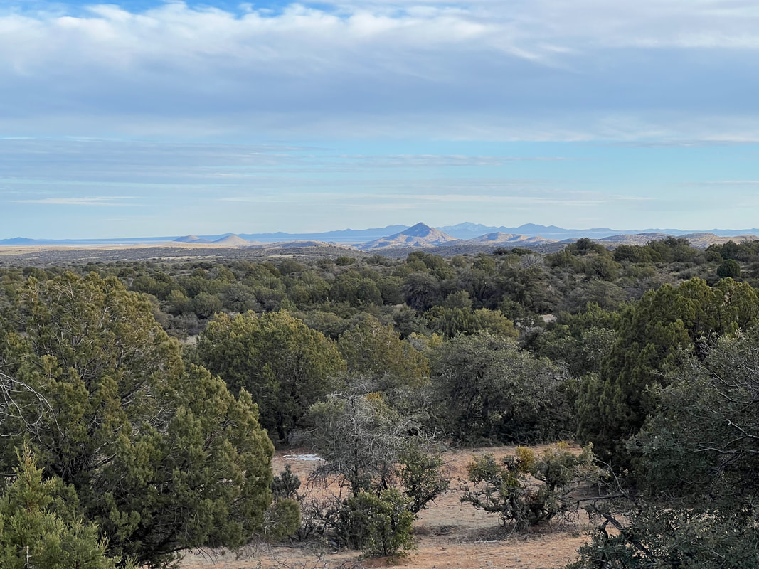
Saguaro National Park has two locations in Tucson, one on the east side of the city and one on the west.  The main headquarters and Visitor Center is on the east side, and we’d already hiked near the west side location, so we wanted to visit the east side.  According to the park volunteers who helped us plan a hike, the saguaros on the east side are bigger and older.  There may not be quite so many of them, but there are still enough that they call that area of the park a cactus forest.  And, they are huge and very old.  We learned that they are very slow growing and don’t even flower until they are about 35 years old, and don’t start to get their iconic branches until they are almost 100.  The big ones with lots of arms are estimated to be 150 years old or more.  We drove the 8-mile loop around Cactus Forest Drive before heading to the other side of the park for a hike.
Picture
Picture
After driving around the loop road, we left the Rincón Visitor Center area and drove around to the edge of the park to a trailhead.  Tom had mapped out a hike based on information from the park volunteer, but we were planning to do the hike mostly for exercise since we’ve been hiking in the desert since Texas, and we’d seen a lot of saguaros in the previous day’s hike.  We didn’t think we’d see much that was new and exciting.  

We were, delightfully, wrong.  Maybe it was because of the snow, or maybe it was just that this desert and the saguaros are so different from where we’ve been recently, but we both ended up enjoying the hike and the scenery way more than expected.  We never expected to have to wade through mud in the desert, but discovered that desert mud isn’t all that offensive.  It’s not deep, and not sticky or slippery.  We also didn’t expect to still see snow at 3PM in the desert, but as we climbed we saw snow on the ground, and on some of the saguaros.  What we really didn’t expect was so much water in the desert.  At one point, we had to turn back and replan our route because we came to a stream that was too deep to cross.  Then we climbed a mountain and found a dam with a pretty significant amount of water flowing through it.  Then we heard running water and found a big waterfall, and then another, and another as we hiked around the mountain.  We saw lots of tracks and lots of birds, as well as a bunch of rabbits.  I wanted to see a Gila Monster; we weren’t that lucky, but with all of the surprising things we saw, we ended up being thrilled with the hike.  
Picture
Mud!
Picture
The stream we couldn’t cross, from higher ground
Picture
A very Mountain Pine Ridge type waterfall, in the middle of the desert in Arizona
PictureAnd another!

All afternoon, we’d been asking around about places to camp to avoid going back to the very trashy BLM site of the previous night.  The mud certainly didn’t help, but the whole place was full of trash and dog shit, as well as lots of campers in bad repair, and it had left a bad taste in our mouths.  However, all of the other boondocking sites people had recommended came with the caveat of “the road to get there is a little rough, and it might be slick because of the snow.”  So, we sucked it up and went back to Sawyer Mountain BLM, but instead of parking in the sketchy muddy lot that’s a little off the highway, we went to the more crowded graveled lot closer to the highway that had more nicer campers.  That was an okay choice, and we had a quiet and uneventful night.
0 Comments

The Rest of NM, Including Gila Cliff Dwellings

3/1/2023

0 Comments

 
We didn’t make it to City of Rocks State Park that night.  When the dust storm was done we got on the road, but it was still very windy, so we pulled off at a Walmart less than 10 miles from where we’d waited out the storm.  Quite a few RVs were parked in the Walmart lot, so we knew we weren’t the only ones playing it safe and not driving in the wind.  Since we already had the campsite at City of Rocks, we knew we could get there any time and not have to wait until their late afternoon check in time to park, so we got on the road early the next day.  We stopped for fuel, and when Tom talked to the attendant, he found out that winds at the airport had been clocked at 95mph.  Crazy!

City of Rocks State Park is the kind of place that makes me wish I’d grown up in New Mexico so my family could have gone there for vacation or, even better, lived close enough that we could have gone every weekend.  The City of Rocks is a huge formation that you can wander through and climb on pretty much forever.  Even better, they’ve designed the campground so that campsites are tucked into the rocks, which made us regret getting an electric site since it would have been much more fun to camp in the rocks.  However, the temperatures dipped into the mid-20s, so it was nice to plug in our electric heater and let it run all night.
Picture
Picture
Picture
We left City of Rocks State Park around 8AM because we had been told that while the drive to Gila Cliff Dwellings National Monument was less than 50 miles, it was very curvy and very hilly.  We had heard the same thing from multiple people, and they weren’t kidding!  We started the morning at around 4500 feet of elevation, and to get to Gila Cliff Dwellings we went through a pass that topped out at 7440 feet - and most of that climb was done in less than 5 miles.  However, we were glad to take it slow and enjoy the ever changing scenery since the route leads from the desert into pine forest as the elevation increases.  Because there was a lot of snow at the higher elevations, there was also a lot of water and runoff on the road, which made icy patches.  They were short and didn’t give us any trouble, but we definitely hadn’t planned on driving on ice.
Picture
The Gila Cliff Dwellings were fun to explore.  The NPS has created a path of about a mile which winds through the valley, up the hill to the cliff dwellings, and then back by going behind the dwellings and down to the parking area.  The whole route is beautiful, and the preservation and reconstruction of the actual dwellings is, as expected, quite well done.
Picture
Picture
Picture
Picture
We left Gila Cliff Dwellings and drove back through the pass on our way to a BLM campground on the other side of Silver City.  However, as we were approaching Silver City, we saw miles and miles of mined hills, all crawling with mining equipment and gigantic trucks.  We ;then found an overlook with informational signs for the Santa Rita Copper Mine, so we pulled in to look and take photos.  We were very lucky, because a man who works for one of the companies that provides the drills was there, so he shared a lot of information with us.  Some of it was technical details, but some was more philosophical.  For example, he pointed out that the whole world is trying to go green and make everything electric rather than fossil fuel powered, but most of the copper mined out of the hills is used for electrical equipment.  The copper mining process is obviously not geared towards conservation.  Besides the stripped mountains, we were also told that the copper is extracted by putting the rocks in leach fields and bathing them with cyanide.  And, the gigantic trucks running the ore back and forth 24/7 definitely aren’t running on electricity.  I’ll have to do more research before I form an opinion, but it was definitely food for thought.
Picture
These hills went on for miles and miles.
Picture
This is one tire from the truck in the first photo. Those trucks are BIG.
We left the copper mine overlook and went to a free established campground in the Gila National Forest between Silver City and Lordsburg.  The campground is on the Continental Divide Trail and gets some tent camping through-hikers and -bikers, but it’s also very convenient for RVs.  We found a level spot and took the dogs for a short walk to enjoy the view from the trail.
Picture
Picture

As we were doing our normal evening stuff, we took a look at the next day’s weather for the area.  We were dismayed to find out that yet another high wind advisory was starting the next morning at 8AM, which would make leaving difficult.  We were also dismayed to find out that a Winter Storm Warning had also been issued, and the area was expecting up to 8” of snow the next afternoon and evening, along with temperatures in the teens.  Tom suggested going to bed immediately so we could get up and evacuate by 3AM, but I persuaded him to move the departure time back to 6AM so we could eat, get some sleep, and get up around 5AM rather than the middle of the night.  That’s what we did, and we beat the wind out of New Mexico.  We also decided to skip a couple of sites we were going to see in eastern Arizona, and we headed directly to Tucson, where we pulled in shortly after 9AM.  We did some grocery shopping, went for a hike, and found some BLM land just outside the city to park on for the night.
Picture
We had a great hike through a saguaro forest and around some hills. The dogs couldn’t go, but it was for their own good as the very rocky trails would have shredded their poor feet.
Picture
This is pretty crappy BLM land, with a few campers and overlanders, but also a few more rundown rigs that seem to be permanent despite the supposed 14-day limit. It’s just a big dirt parking lot, and I’m concerned about taking the dogs out because of the amount of garbage and broken glass. However, it’s a free place to sit to ride out the wind storm and the snow, which are both forecast to be much more mild here than in New Mexico.
0 Comments

White Sands National Monument

2/26/2023

0 Comments

 
We left the BLM land and headed towards White Sands National Monument, trying to stay off the interstates.  However, our GPS had us turning every half mile, and was directing us towards some pretty sketchy roads, so we decided to just get on I-25 and head towards Las Cruces.  That turned out to be a good decision, because not only is I-25 relatively lightly traveled which made the driving easy, but it got us to White Sands in time to drive through the park and take a hike that day, rather than finding a camping place to spend the night before touring the park the next day, when a wind storm was predicted.  

White Sands is terribly beautiful.  The park is aptly named, and all you can see is miles of white sand dunes in every direction to the base of the mountains.  We drove to the end of the park road and got out with the dogs to take a hike through the dunes.  White Sands is different from other parks we’ve visited because park visitors can do whatever they want, go wherever they want, and dogs are welcome as long as their owners clean up after them.  We saw people trying to sled down the dunes on flying saucers purchased in the gift shops, and they can do it wherever they want.  We’d talked about getting a saucer and trying it, but decided not to because we didn’t want to fill our clothes with sand.  When we saw people doing it, we were happy with our decision because it didn’t really look like that much fun and the saucers moved very slowly through the sand.  People were walking all over, and it doesn’t really matter because no matter what they do or where they go, the wind will erase any evidence of their passage within a few hours.  We took the dogs on a five mile loop trail, but after a mile and a half of climbing up and down dunes, we turned back.  We used the dogs as an excuse, but I was pretty ready to turn around and stop trudging through the sand.  It’s like the beach without the ocean, and most of the reason I consider myself a woods person rather than a beach person is because I don’t like the sand, so the sand without the water isn’t much fun for me.  But, it is incredibly beautiful and unlike anything I’ve ever seen.
Picture
Picture
After playing in the sand, we drove about five miles from the White Sands entrance to a free boondocking campground we’d found on iOverlander and FreeRoam.  It’s on the grounds of the Holloman AFB, and the campsites are around the “lake,” which is actually a wastewater evaporation pond.  This means it’s very pretty, but you shouldn’t touch the water, which was fine for us. A lot of campers were there, some obviously overnighting like us, but also some who looked like they were set up for an extended stay.  Despite the lack of management, it was very clean, and everybody we encountered was very friendly.  And, as advertised, the sunset was stunning.
Picture
With the windstorm predicted for the next day, we didn’t make any plans that night.  In the morning, the wind hadn’t started yet, so we looked at the map and booked a campground near the Gila Cliff Dwellings National Monument so we could get there and get to the park the next day.  However, by the time we took the dogs for a short walk and got on the road, the wind had started.  As we came through the Organ Mountain pass on US70 just east of Las Cruces, the wind hit us like a truck, and we looked ahead into a dust storm.  Tom wisely took the next exit off the highway and found a parking lot, just before our phones buzzed with the dust storm warning.

We’re still sitting in the parking lot, three hours later.  Most of the dust seems to have passed, but the wind is still rocking and rolling the camper.  Maybe we’ll make it to the campground tonight, and maybe we won’t, but in any case we’re safe in our camper and not being blown off an overpass or hit by an out of control truck.
This video is before the dust storm really hit, but you can hear the wind.
0 Comments

South out of Albuquerque

2/26/2023

0 Comments

 
We spent a day longer than planned in Albuquerque because when we went out of the camper on Thursday, we noticed an icicle hanging off the back corner under the water heater and pressure tank.  We’d noticed water dripping from that area before, but we’d never had the chance to trace where it came from by following the ice trail.  The diagnosis was that it was the plastic fittings going into the water heater, and the evidence that this was not a new problem was in the rusted fittings.  Since Todd and Tatiana live just a block from a Home Depot, and we were parked in their paved driveway, and we had Todd’s camper van expertise to help, we decided that rather than hit the road we would fix the leak.  The leak was fixed by early afternoon, but since we wouldn’t have enough time to get anywhere if we left that late, we decided to get our grocery shopping done, fill our propane tank, take a walk along the river, and have one more meal with Todd and Tatiana. 
Picture
From the trail on the other side of the river, we could see Todd & Tatiana’s neighborhood on the opposite bluff.
Friday morning, we didn’t have any distractions and were up and out early, heading south towards the Salinas Missions National Monument.  We took the back roads, so on the way I pulled out All Trails to look for a hike.  We were in Cibola National Forest, and the trailhead for a ~5-mile loop hike up a mountain was just a few miles in front of us.  We easily found the trailhead parking lot, and set out on the trail for a beautiful hike to the top of a mountain.  As we climbed, we found places that were still snow covered, and we had to squish through a lot of muddy patches, but overall it was a relatively easy hike with lots of beautiful vistas.  Princha got used to the snow, and we returned to the camper in time for a cheese and crackers lunch before heading south.
Picture
We hiked around the mountain to the right to the snow covered peak in the distance.
Picture
Picture
Picture
It’s funny - to me - to see a cactus in the snow.
After cleaning some of the mud off the dogs and eating lunch, we headed south towards the Salinas Missions National Monument.  This park is another one of those spread out at various sites over many miles, and we decided to go to the Quarai site, which is an old mission which was abandoned before it even had much use because the crown and the church couldn’t agree on who the Native Americans should work for, and whether they should be saved or taxed. Whatever the history, it was interesting to walk through the ruin and around the grounds.
Picture
Picture
Picture
When we left the Quarai site, we looked for a place to stay for the night so we could go to the Abo site in the morning.  However, the closest camping we could find was on BLM land about 60 miles away, so we bypassed the Abo ruins and headed towards Soccoro towards a spot we’d found documented on both iOverlander and FreeRoam.  It was our first campsite on BLM land, and it was beautiful.  We followed another overlander van onto the BLM land, and he picked a site near the top of the hill, so we kept going and found a perfectly level and perfectly quiet spot in another mile.  We considered going another mile or so towards the canyon to get away from the highway, but decided it wasn’t worth it for one night.  Due to the hill, we couldn’t even hear the highway, even though it was probably less than 2 miles away.  
Picture
Picture
Picture
After a quiet night, we pulled out in the morning and headed towards White Sands National Monument.
0 Comments

Albuquerque and Petroglyph National Monument

2/23/2023

0 Comments

 
We found Todd and Tatiana’s house at the edge of the city and managed to squeeze our camper into their driveway next to their camper van.  Our original plan - once we planned to go to Albuquerque - was to stay there for a couple of days before heading towards White Sands. On Monday, it looked like the plan would work as we had a good visit and Todd took us to the Petroglyph National Monument, which is within walking distance of their house. But, the weather kicked in again and we ended up delaying our departure until Thursday due to high winds and white-out conditions. But, just as we were glad of the ice storm in Texas for more time to visit with them, we have thoroughly enjoyed our time visiting with them at their home. 

The Petroglyph National Monument is spread out over a number locations in the northwest side of the city. Living so close, Todd has spent a lot of time there, and it was a huge advantage to us to have him take us since he pointed out a lot of petroglyphs we would have never seen on our own.  I took a ton of photos because, as with the rock art, they’re easier to see through the camera than with your eyes. 
Picture
Picture
Picture
Picture
The extra days in Albuquerque also let us visit with their now adult daughter Aspen, and it was truly a pleasure to get to know another adult child as we visit old friends with now grown up children. We didn’t especially enjoy howling winds, a dust storm, blizzard conditions, and cold, but being in a nice warm house with good friends definitely made the extra days worth it. Plus, Albuquerque is a beautiful city, and even when the weather wasn’t great the sunsets and the view were amazing. 
Picture
Picture
0 Comments
<<Previous
Forward>>

    Meet the Moonracers

    Tom and Marge are taking Moonracer Farm On The Road Again.  Follow our journey to build an expedition vehicle and travel!


    Overnight Stops

    Archives

    January 2024
    September 2023
    August 2023
    July 2023
    June 2023
    May 2023
    April 2023
    March 2023
    February 2023
    January 2023
    December 2022
    November 2022
    October 2022
    September 2022
    August 2022
    July 2022
    June 2022
    May 2022
    April 2022
    March 2022
    February 2022
    January 2022
    December 2021
    November 2021
    October 2021
    September 2021
    August 2021
    July 2021
    June 2021
    May 2021
    November 2019

    Categories

    All

Web Hosting by Netfirms